Cemetery Maps Collection
Digital Archives
About the Collection
Maps are often a key part of cemetery records as they document the exact location of plots that have been purchased or assigned. This collection brings together individual maps gathered from across Utah.
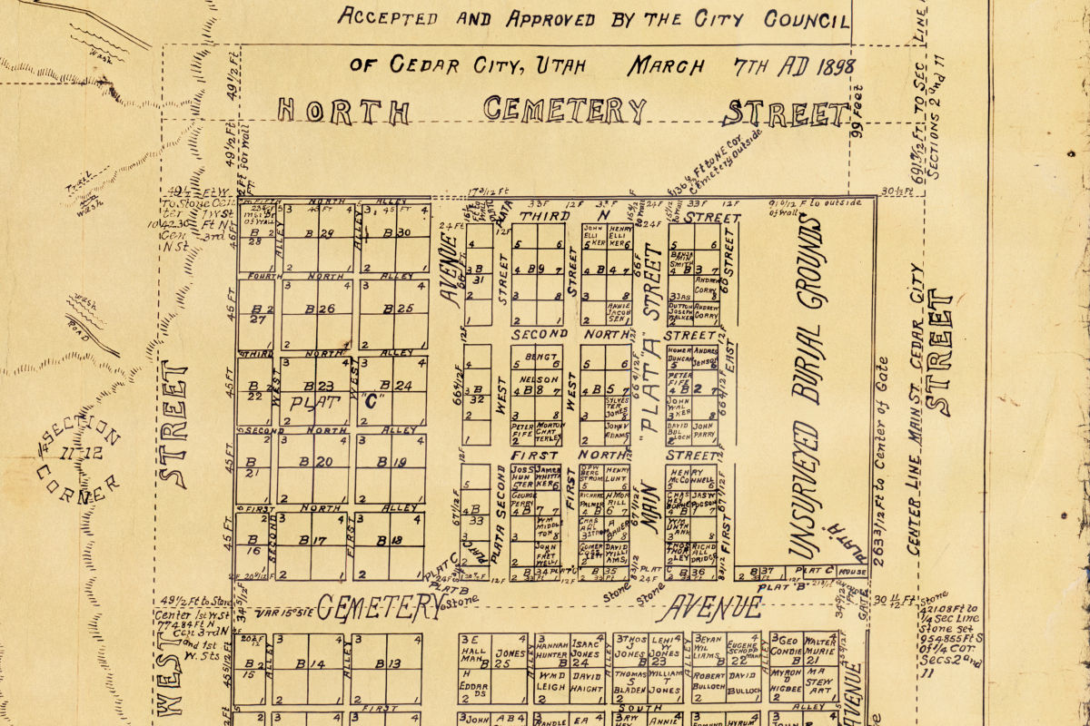
Cedar City (Utah) City and cemetery map
This series contains a blueprint copy of a map of Cedar City. The map was created by the city surveyor and accepted by the city council in 1902. It shows streets, blocks, lots, property owners, township and range sections, and an inset map of the city cemetery. Because it includes the city cemetery, this copy of the map was used by the cemetery sexton's office.
Honeyville (Utah) Cemetery maps
This series contains maps of the the Honeyville City Cemetery and the Call's Fort Cemetery, both operated by Honeyville City. The maps show the layout of the cemeteries, plot locations, and burial locations and are used to track the location of graves.
Laketown Cemetery Maintenance District (Utah) Maps
This series contains maps of the the Honeyville City Cemetery and the Call's Fort Cemetery, both operated by Honeyville City. The maps show the layout of the cemeteries, plot locations, and burial locations and are used to track the location of graves.
Levan (Utah) Cemetery maps
This series contains a record book maintained by the court that documents who checked out the assorted civil, criminal, and probate record books created by the court between 1956 and 1994. Information recorded includes the case number in question, the name of the individual checking out the material, the date the material was checked out, and the date material was returned.
Logan (Utah). Parks and Recreation Cemetery maps
This series contains two maps of the cemetery, showing the layout of the cemetery with roads, plats, blocks, lots, and lot owners. The paper copies held by the cemetery are blue-line prints, one undated and measuring approximately 18" x 24" and the other dated 1968 and measuring approximately 42" x 60".
Morgan (Utah) Cemetery maps
This series contains various maps used to document the location of plots and burials in Morgan City Cemeteries 1 (South) and 2 (North). The oldest surviving maps are ink-on-linen drawings. More recent maps are black or blue line copies on paper and ink on mylar.
Plymouth Cemetery Maintenance District (Utah) Map
This series contains a map showing the layout of the cemetery with roads, walkways, lots, and names of lot owners. The map is an ink-on-linen drawing with additional information added over time. It was used to keep track of the location of burials in the cemetery.
Smithfield (Utah) Cemetery maps
This series contains a map of Plat B in the Smithfield Cemetery, copied in 1952 from an earlier 1931 map. The map shows the layout of the plat with roads, walkways, and lots with numbers and owners. The map also notes the location of the earliest burial in the cemetery and roadways that could be sold as burial lots.
Warren-West Warren Cemetery Maintenance District (Utah) Maps
This series contains two maps showing the cemetery layout and location of burials. One of the maps is older, but undated. It is drawn in pencil and shows location of graves with names listed along the edges of the map. The second map is a photocopy of a map drawn in 1958. It does not show individual burials, but shows the layout of blocks and lots in the cemetery.
Wellsville (Utah) Cemetery map
This series contains a map showing the layout of the cemetery with roads, blocks, lots, and lot owners. It was created in 1971 and approved by the Wellsville City Council. The map was modified and reprinted in 1996 from a computer file. Handwritten information has been added since that time.