The Law of the River: Compact and Development
This is the first in a series of blog posts that will explore records held by the Utah State Archives that help illuminate the story of Utah’s role in the larger western movement to tame and develop the Colorado River as a vital resource in the arid west.
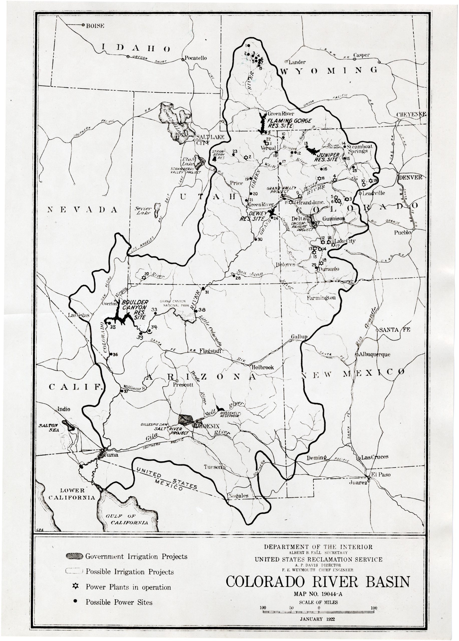
THE COLORADO RIVER BASIN
The Colorado River originates in the high Rocky Mountains of Colorado, before making its 1,750-mile journey to the Pacific Ocean, emptying at the Bay of California. Along the way it gathers run-off from a drainage basin 244,000 square miles in length, carves out the dramatic cliffs and canyons of southeastern Utah and Arizona’s Grand Canyon, and carries a silt load higher than any other river of comparable size.
The Colorado is an international river, draining water from seven western states, (Wyoming, Colorado, Utah, New Mexico, Arizona, Nevada, and California) as well as Mexico. Moving from the highest peaks of the Continental Divide down to the low, arid deserts of the Sonoran and Mojave, the Colorado River is a vital artery running throughout some of the American southwest’s most spectacular (and unforgiving) landscapes.
For much of human history, the Colorado River, and its tributaries, have served a vital role in providing life-giving water to the region’s inhabitants. Many Indian tribes of the southwest practiced dry farming and simple irrigation techniques using scant available water resources. This model was later expanded on by white settlers in the region, particularly the early Mormon settlers of Utah.
The Colorado gained some measure of national celebrity from the famed expeditions taken down it by John Wesley Powell, first in 1869 and again in 1871-1872. These scientific trips gave Americans a better sense of the canyon country frontier, as described vividly by Powell, as well as providing Major Powell with some sense of the harsh environmental realities imposed by the arid deserts of the southwest.
CALIFORNIA’S THIRST
The story of the Colorado River in the 20th century, a period when it would become the most legally regulated river on Earth, begins with the explosive population growth witnessed in Southern California at the turn of the century. Water projects that carried water from California’s Owens Valley helped fuel tremendous growth in Los Angeles and the San Fernando Valley.
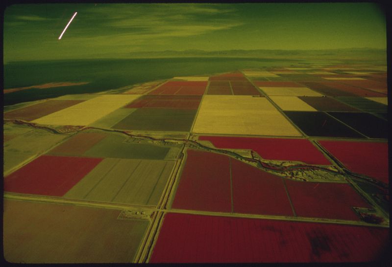
Fields in California’s Imperial Valley irrigated with Colorado River Water (EPA photograph from National Archives and Records Service).
Similar efforts to carry (and control) Colorado River water to the famously dry Imperial Valley for irrigation and flood control raised serious questions among all of the western states in the Colorado River Basin. The legal history of water in the west had placed water rights under the provision of prior appropriation. Simply put, the first to develop a water right was the first to own it: “first in time, first in right.”
What if California’s rapacious, and seemingly unending, thirst lay claim to the bulk of available Colorado River water, and blocked anyone upstream from making later use of it? What if earthworks built by California to tame unpredictable floods from the Colorado locked in place an inequitable infrastructure, forever in favor of the Golden State?
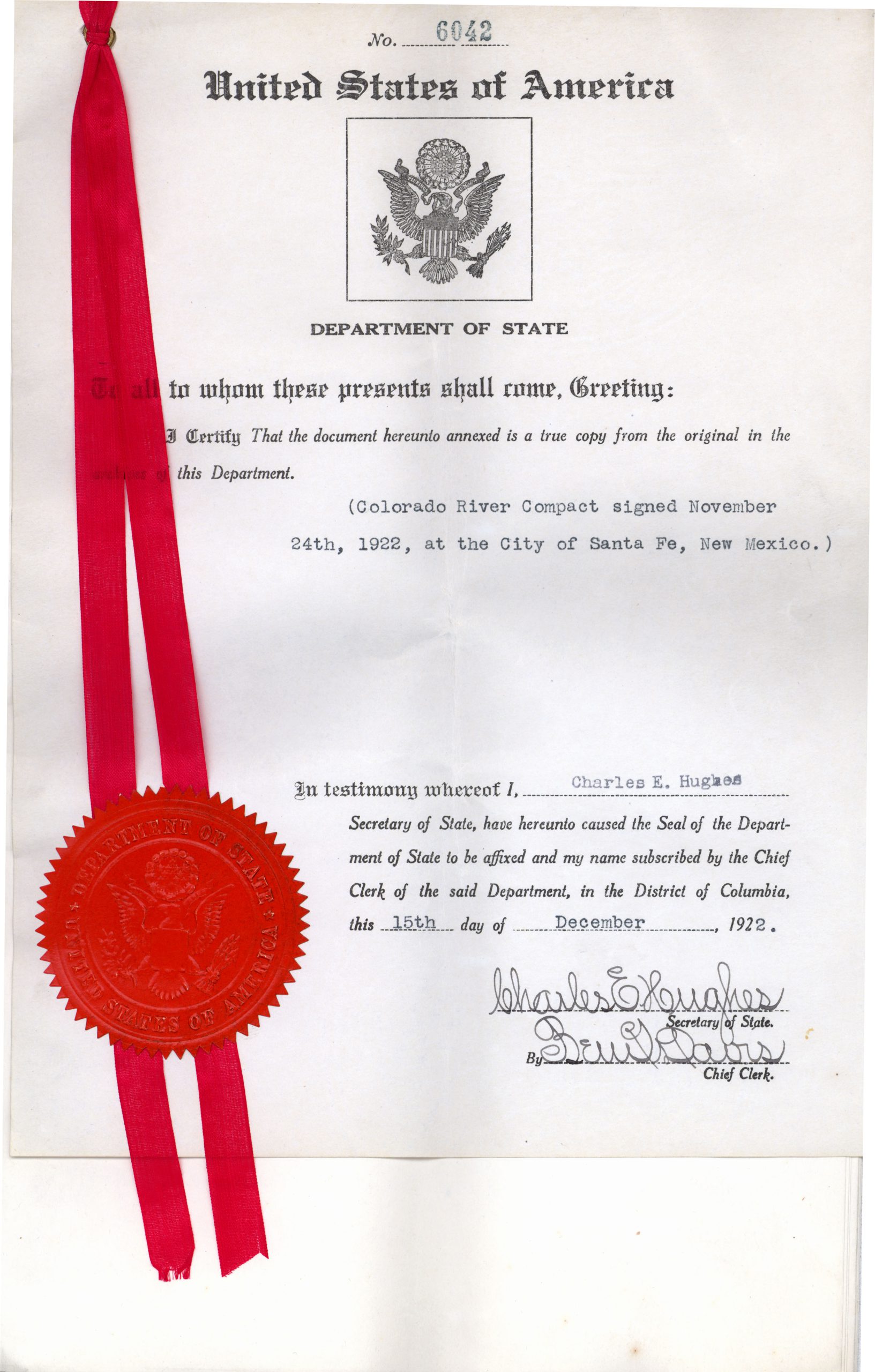
With these fundamental questions in mind, representatives from the seven basin states (as well as U.S. Commerce Secretary, Herbert Hoover) met on January 26, 1922 and began work on an expansive interstate compact to regulate and share the Colorado River among all of its interested parties.
NEGOTIATING A COMPACT
In the eleven months between January and November, 1922 multiple meetings were held that would culminate in the Colorado River Compact. Over the course of its legal history, the various compacts, agreements, and legal decisions that have been placed on the Colorado River have come to be known as “the Law of the River.” In this regard, the Colorado River Compact is the backbone that serves to connect everything else together.
Utah’s representative to the 1922 negotiations was State Engineer, R.E. Caldwell, having been appointed by Utah Governor Charles Mabey. Records from the State Engineer documenting Caldwell’s work on the Colorado River Compact (as well as other river-related records from the office) are held by the Utah State Archives in series 13912.
The major provisions ultimately agreed to in the Colorado River Compact were unique, and critical in dictating all future development made on the river.
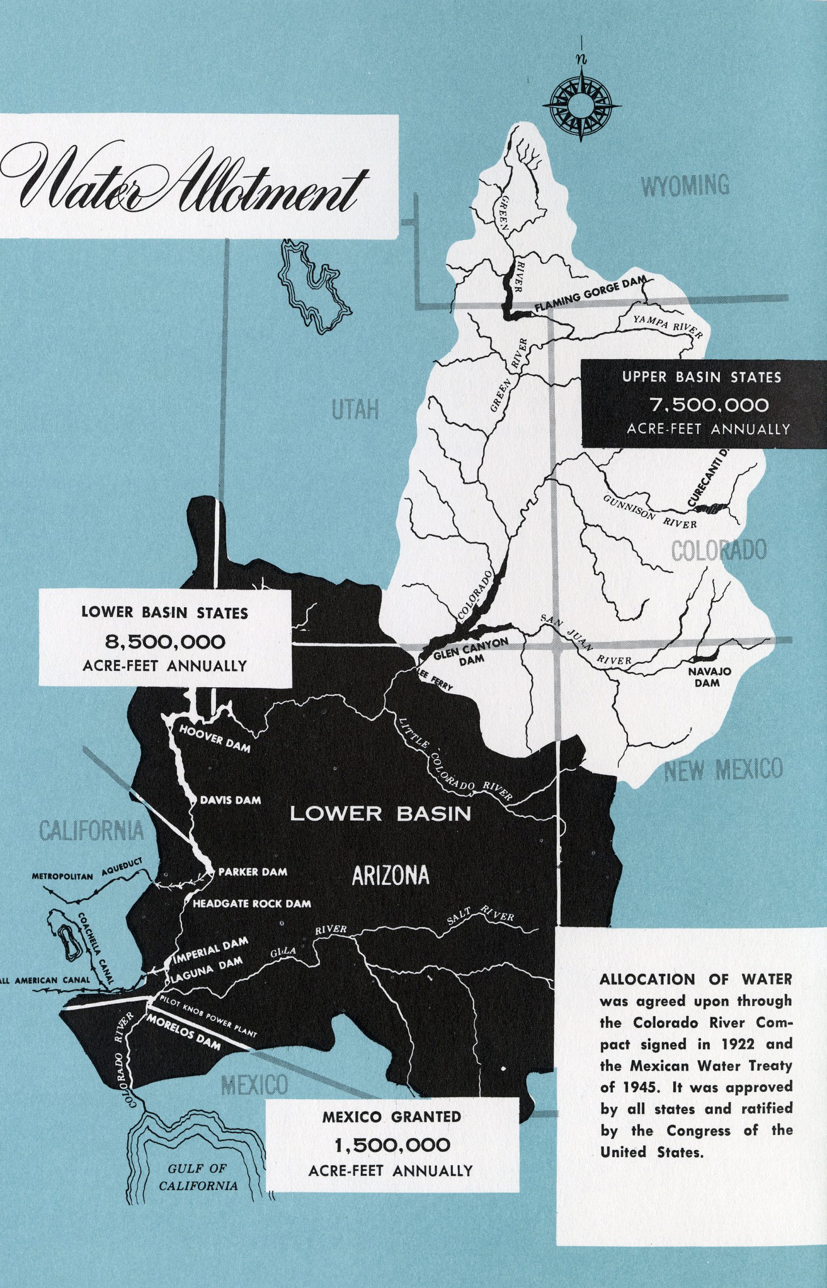
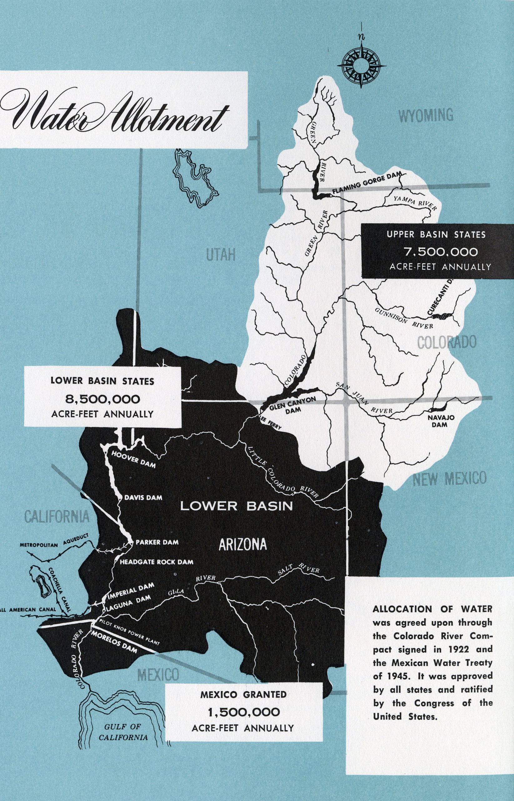
The first of these provisions was the decision to effectively create two separate artificial basins within the larger Colorado River Basin. The Upper Basin was to consist of the mountain states of Wyoming, Colorado, Utah, and New Mexico (the states that provide the bulk of the flow to the river). The Lower Basin was formed from Nevada, Arizona, and California. The line of demarcation separating these two units was designated at Lee’s Ferry in northern Arizona.
A second consequential provision of the compact stipulated how much flow from the river each basin was eligible to claim. Calculations for the Colorado’s annual flow were taken from dubious readings maintained by the Bureau of Reclamation during a multi-year period that saw the river rage higher than at any other point in its recorded history.
Based on these flawed Bureau estimates, the flow of the Colorado River averaged 17.5 million acre-feet of water annually. The Colorado River Compact stipulated that 15 million acre feet of this share was to be divided equally between the Upper Basin and the Lower Basin. The Lower Basin was awarded an additional 1 million acre feet under the threat that its representatives would walk away from the negotiations without that bonus allotment. The final 1.5 million acre-feet of flow was reserved for Mexico, a number that was cemented into law by an international treaty in 1944. It was left for the states within each basin to determine the percentage of their allotted flow that would go to each state.
DELAYED RATIFICATION
Each member representative from the compact negotiations signed the accord and returned to their respective state, leaving final ratification of the compact to state legislatures or voters. In Utah, the Colorado River Compact was ratified immediately by the Utah state legislature during its 1923 session, and the compact was filed with the lieutenant governor, where it is currently found in series 20221.
The process of ratifying the agreement did not come easily for other states, however, as interstate squabbles arose over a host of issues. The most divisive of these occurred between Arizona and California, who couldn’t agree on how to divide the 8,500,000 acre-feet granted to the lower basin.
For six years the Colorado River Compact languished until the U.S. Congress intervened with passage of a bill that simultaneously provided a path for formal ratification of the Colorado River Compact, as well as authorized the Bureau of Reclamation to begin work on what would become the largest dam project on Earth, up to that point.
BOULDER CANYON PROJECT ACT
The Boulder Canyon Project Act of 1928 paved the way for nearly a century of reclamation activity on the Colorado River that has left a decidedly mixed legacy. One major provision of this piece of legislation was to make the Colorado River Compact legally binding. It sought to do this by settling the feud between California and Arizona over their shared water allocation. Accordingly, California was limited in its annual diversion to 4.4 million acre-feet per year, while Arizona was granted 2.8 million acre-feet (leaving the remaining 300,000 acre feet in the lower basin to Nevada). The Boulder Canyon Project Act went on to say that the Compact would become legally binding upon ratification by six of the states, one of those states needing to be the compact’s biggest player, California. This was accomplished, in spite of the fact that Arizona (out of protest) refused to formally ratify the compact until 1944.
In 1927, the year before the Boulder Canyon Project Act was passed, the Utah legislature formally repealed their original 1923 ratification of the compact. This was followed, in 1929, by a second ratification of the Colorado River Compact by the state of Utah, as well as the creation of a Utah Colorado River Commission. This commission, whose records can be found in series 165, was made up of three members appointed by Governor George Dern, and tasked with representing Utah’s interest on all matters related to the Colorado River.
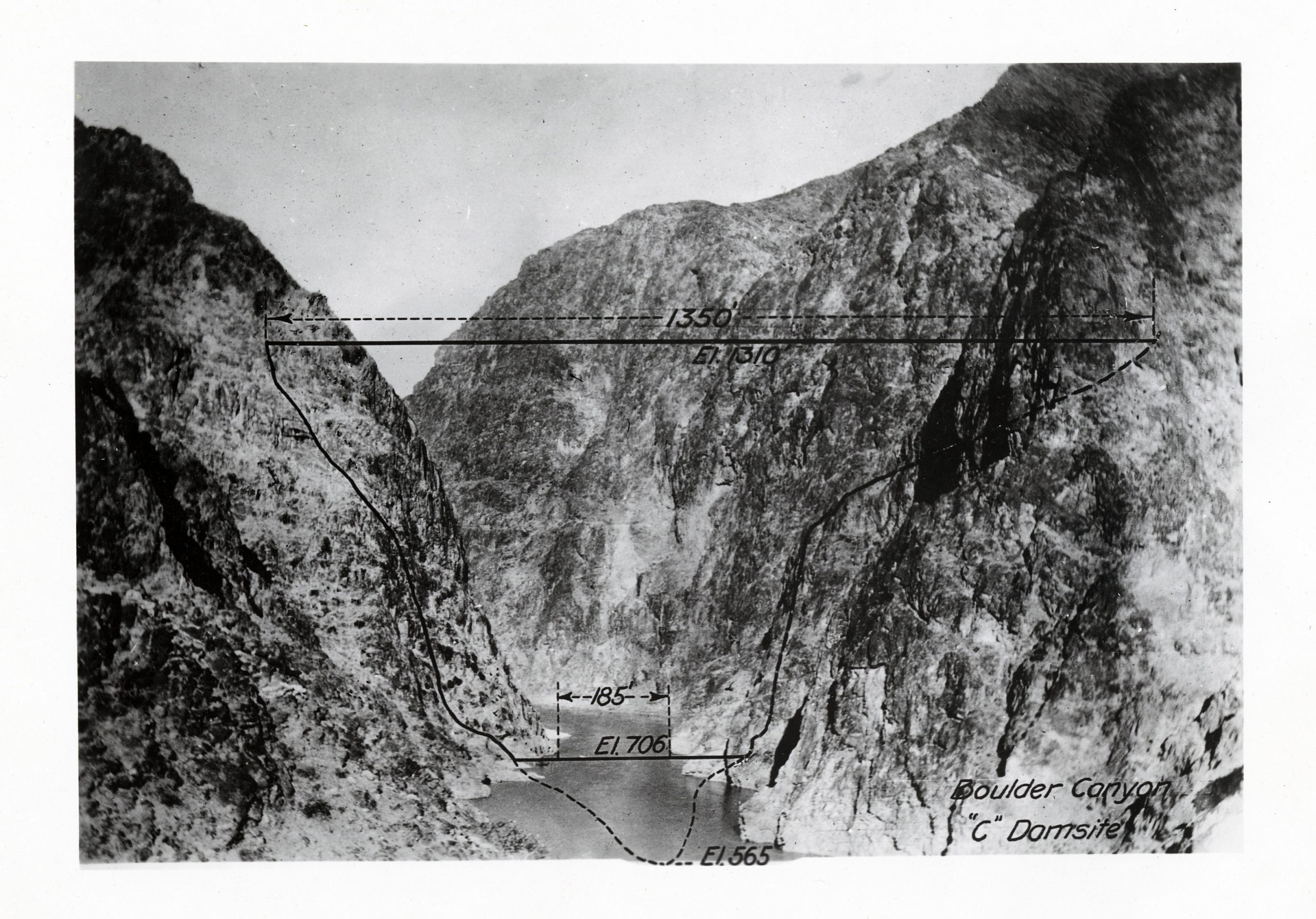
The second major provision of the Boulder Canyon Project Act, was a mandate to build the first major dam site on the Colorado River. The location chosen for this was in the Black Canyon near Las Vegas. Construction on the Boulder Dam (later renamed Hoover) commenced during the heart of the Great Depression, in 1931. Over the course of six years thousands of workers built massive diversion tunnels, rerouted the Colorado River from its bed, sunk the foundations for the dam at bedrock, and ultimately constructed a 726′ plug in the Black Canyon that could hold back up to 28,537,000 acre-feet of Colorado River water in the impounded area named Lake Mead.
The water held at Hoover Dam has served a variety of purposes in the ensuing decades. A canal built downstream (named the All-American Canal) carries water from the Boulder project west, into California’s Imperial Valley. The water of Lake Mead has been used for recreation, irrigation, industrial use, and municipal use in both Las Vegas and the cities that mushroomed in southern California throughout the 20th century. Hydroelectric power derived from the dam has played a pivotal role in growing the populations in one of North America’s most inhospitable environments. Electricity generated at Hoover Dam has helped build industry, attract tourism, and provide critical hydration and conditioned air in a region often devoid of both.
VIEW FROM THE UPPER BASIN
The Hoover Dam served as the first vivid example of what a massive, federally backed water project on the Colorado River could look like. Upstream, leaders of the Upper Basin states kept a keen eye on the tremendous growth in the Lower Basin spurred by the Boulder Canyon Project. In many ways, the dam provided a template for future projects in the Upper Basin, as well as providing incentive for the Upper Basin states to organize into a coalition, lest they eventually lose their allotted water share to future projects in the Lower Basin.
Evidence that developing the state’s Colorado River share was a pressing issue for Utah leaders is found in records kept by two different governor’s of that era. Governor George Dern (1925-1933) maintained a subject file on the Colorado River Compact (series 206) that reflect Utah’s interaction with other western states on Colorado River issues, as well as the negotiations and discussions that went on with the 1928 Boulder Canyon Project.
Dern’s successor, Governor Henry Blood (1933-1941), in turn, maintained a Colorado River correspondence files (series 22918), which contains legislative bills, resolutions, general correspondence, minutes and reports related to Utah’s earliest attempts to help devise an Upper Basin reclamation plans to assure its share of water as designated in the Colorado River Compact of 1922.
The Colorado River Compact and the Boulder Canyon Project Act provided the thread upon which all of the states in the Colorado River Basin would ultimately go about drawing on their share of the Colorado River’s seemingly vast potential.
The story of Utah’s participation in developing a reclamation plan for the Upper Basin, and the implementation of projects based on that plan, will serve as the story for the next blog in this series.
SOURCES
Reisner, Marc. Cadillac Desert: The American West and Its Disappearing Water. New York: Penguin Books, 1993.
Worster, Donald. Rivers of Empire: Water, Aridity, and the Growth of the American West. New York: Oxford University Press, 1992.
Recent Posts
Authors
Categories
- Certification/
- Digital Archives/
- Electronic Records/
- FAQ/
- Finding Aids/
- General Retention Schedules/
- GRAMA/
- GRAMA FAQs/
- Guidelines/
- History/
- Legislative Updates/
- News and Events/
- Open Government/
- Records Access/
- Records Management/
- Records Officer Hub/
- Records Officer Spotlights/
- Research/
- Research Guides/
- RIM FAQs/
- Roles and Responsibilities/
- State Records Committee/
- Training/
- Uncategorized/
- Utah State Historical Records Advisory Board/
